


Google Street View: Our Fave Road Condition Travel Trick
- Jan 31, 2025
- 5 min read
Updated: Jul 28, 2025
Question: How can I determine road conditions and decide what kind of vehicle to rent before my trip?
This trick works best for the GENERAL condition of roads along your route. Prior to our trip to Colombia, I could not get a straight answer about the two major routes dissecting the country's mid-section. Forum advice was 5-10 years old.
Given the speed at which investment in new Colombian roads is advancing, everything I learned turned out to be woefully outdated. And honestly, any advice I give about roads will be the same in short order. Though, expect small stretches through rugged mountain passes to be reliably unreliable for a long time yet. This is where our travel trick utilizing Google Street View really earns its keep.
Our Hero Travel Trick for Roadways: Google Street View
If you're lucky enough to be checking an area where one of their camera cars has passed within the last year, provides on-the-ground imagery to take the mystery out of your driving. This is great for deciding which kind of vehicle to rent. And since different vehicle sizes mean big price differences, that's key info. In much of Europe, streets can be so tight that having a hyper-compact vehicle can be a life-saver. Whereas, driving through rural areas in South America without a lot of infrastructure, big rainy seasons, and/or unstable geology might demand a vehicle with 4WD or, at the very least, more clearance.

Plus, you never know if the road you've followed for three hours is suddenly going to end with a precarious drop-off and...
In Costa Rica, that's exactly what happened. Just after dark, we were driving along a well-maintained dirt road with a speed limit of 80km/hr (50mph) and suddenly... the road disappears.
SCREEEECH!
Some places don't have an agreement permitting Google Street View cars to drive their interior roads. (Looking at you, Costa Rica). We were surprised that Costa Rica was seriously light on image data, while Colombia's waaaay rougher roads were very well-mapped, especially through areas that were arguably more challenging to navigate than Costa Rica.
Now, you're certainly not going to use this trick to spot check an entire country. But if you know you're going someplace that's pretty isolated, information is scant, and rumors abound of the inconsistency of the roads, it's a great idea to drop in from on-high (via Google Maps) and take a closer look.
Step-by-Step Guide to Checking Your Route on Google Maps
To use Google Street View for what I like to call "spot-checking my route", open up the Google Maps app on your device. This is a bit easier on a laptop or desktop computer, but we'll assume you're already on the road.
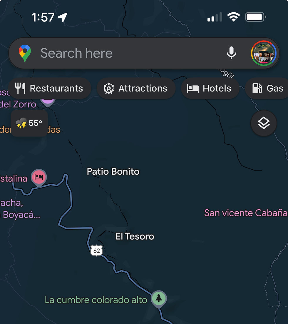
Once you've got Google Maps open, locate a rural route you're planning to drive. In the image here, you'll see a portion of Route 62, which cuts across Colombia's three branches of the Andes that dissect the country like a giant claw mark.
There are several things I could focus on, among them: river crossings and rugged mountain terrain. You might even wish to catch a glimpse of the sort of tiny towns dotting the map along your route.
In terms of terrain, let's say I'd like to spot-check the road conditions along some of the more rugged mountain passes. To focus my search, I'm going to toggle layers and select terrain.
In the image, you can see the layer button highlighted. Toggled, you can now identify the darkly shaded greens that indicate rugged mountain areas.
On my device, I'll zoom in on those darker green areas along my route. I will zoom in close enough to be able to tap the route itself, highlighted in blue. This drops a pin, and if you're close enough to the road in question, an image should appear in the bottom left corner, indicating Google Street View. If there's no image, Google's camera cars may not yet have mapped this area.

Click on the image in the bottom left corner. This takes you into Google Street View. For the uninitiated, GSV comprises photos taken every few seconds from a 360-degree camera system mounted on top of a specifically outfitted car, whose driver has one job: drive around the country.
What this means for you is the ability to literally move through connected photographs and navigate along a given route. Not only can you see the road, but you'll be able to peek in every direction with about as much clarity as you might from the interior of your rental car.
Crucially, there's one more very important piece of information you'll want to determine before taking these images as gospel for route-planning: the image date.
Not to be confused with the Google image copyright top-center. The route photo's date, as well as an archive of historical photos taken by GSV from this location, can be accessed at the bottom of the screen.

For my purposes, an image date of March 2024 is pretty helpful. No, I can't see what mayhem the latest rainy season hath wrought. But I can get a general idea of what I'm up against.
In the image to the right, I can see that at least part of the mountain pass has pretty great roads. After a bit more spot-checking, I discovered that there were only a few areas that should concern me. We drove through most recently in the rainy season, and some landslide-prone areas were clear, but had yet to receive a fresh gravel/paving treatment.
As a result, they were glorified mud trails, featuring huge puddles. The road narrowed down to a single "lane", and a pair of flaggers stood on opposite ends of the single-route pass accepting tips for keeping in radio contact and letting cars pass.
Ultimately, you've got to assess your appetite for risk. Sure, there's an outside chance you drive for three hours only to find your road rendered completely impassable due to a landslide. That's the nature of the trekking into the unknown. If you take the risk, you may as well plan for the unexpected. Having to turn around isn't fun, but it's just the way it goes sometimes.
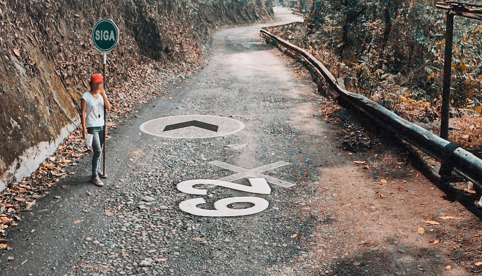
Some more GSVs from our drive. By no means the worst driving conditions we've experienced. But thanks to these images, we opted for an SUV rental with good clearance. About 85% of the time, we didn't need it. But the cost was ultimately worth it for the few times we needed to roll up our cuffs.
Notably, in Costa Rica, (where Google Street View is super limited, to date) we rented the most useless SUV ever. Not only were the tires made of paper, the engine was gutless. After a few close calls, we were forced to modify our route. Next time we go, we're getting a car with high-clearance, mud tires, and a SNORKEL!


Technically, these are roads... appetite for risk <<< analyzing >>>
Wanna Make the Roadtrip Smoother Than a Smoothie? Click below to check out curated portable snack options for traveling with (and without) small children.
Visit GEAR UP For More Outstanding Travel Essentials

Copyright © WS&T. All rights reserved.


Comments